Road Photos & Information: Queensland
Metroads

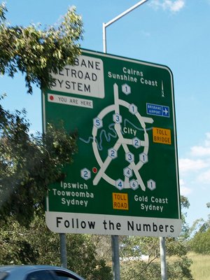
Brisbane Metroad System Information Sign, Ipswich Motorway at Redbank, March 2007. Image © Rob Tilley
Brisbane is one of two Australian cities to have a Metroad route marking system (the other was Sydney). Introduced to Brisbane in 1995, the initial system consisted of routes 1-5 but a sixth was added following the opening of the Gateway Motorway extension (Southern Brisbane Bypass) in 1998.
Metroads form the priority routes into and through the metropolitan area. However with the implementation of alphanumeric routes in 2000 some Metroads have been replaced with alphanumeric designations.
- September 2000: Metroad 1 was decommissioned in favour of M1, which covers the Pacific Motorway from Tugun to Eight Mile Plains and also the Gateway Motorway from Eight Mile Plains to Bald Hills.
- 2005: M1 was extended to take in the Bruce Highway from Bald Hills to Cooroy.
- October 2006: Metroad 5 along Western Freeway between Darra and Toowong was replaced with M5. 1
- June 2008: Signs showing M2 along Logan Motorway installed initially installed at Browns Plains, replacing Metroad 4, with sign rollout along the Logan Motorway and Gateway Motorway between Drewvale and Goodna, completed by March 2009. 2
- August 2008: Signage along Metroad 3 (Pacific Motorway from Eight Mile Plains to Coronation Drive Brisbane) was replaced with signs bearing M3. 1
- November 2008: Metroad 2 (Ipswich Motorway) was replaced with M2 west of the Gailes interchange. Metroad 2 from the Logan Motorway interchange to Granard Road renumbered to M7, and Ipswich Road renumbered A7. 2
- December 2008: Completion of M3 signage rollout along Pacific Mwy from Eight Mile Plains to Coronation Dr in Brisbane. Metroad 3 has also been elimnated, replaced with M3 from Bowen Hills to Bald Hills, with A3 used on the non-freeway standard sections. 2
To view each gallery, click or tap on a route number or preview image below.
1 Michael Greenslade.
2 Trent Thomson.
2 Trent Thomson.

