Statistics:
- Length:
- 751 km (Toowoomba to Yarraman: km)
- Termini:
- Northern: Bruce Hwy (A1), Gracemere
- Southern: New England Hwy (A15 / NR42), Glengallan
- Suburbs, Towns & Localities Along Route:
- South Toowoomba, Toowoomba, North Toowoomba, Harlaxton, Highfields, Cabarlah, Geham, Hampton, Pechey, Crows Nest, Pinelands, Glenaven, St Aubyn, Wutul, Cooyar, Upper Yarraman and Yarraman
Route Numbering:
- Current: A3
- Multiplexed with: A21
- Former: 42 61 85
- Road Authority Internal Classification:
- 22A (Yarraman to Tooowoomba)
- 22B (Toowoomba to (Glengallan (Warwick))
General Information:
A3 is a major route in eastern Queensland, connecting the Darling Downs region to the northern coastal regions of the state. It's also not connected to the M3 / A3 route in Brisbane.
It consists of mostly rural highway roadway, but passes through several of Queensland's important regional centres.
Multiplexes along the route include:
- A21 (Toowoomba Connection Road), for 400 m, Toowoomba.
History:

Intersection Directional Sign:
ID sign at the junction with Bridge St in Toowoomba, April 2005. A2 has since been renumbered to A21.
Image © Rob Tilley
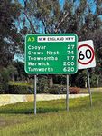
UPDATED Distance Sign:
Reassurance directional sign as New England Hwy (A3) leaves Yarraman, May 2023. Click or tap here for a photo of this location by Rob Tilley from April 2011.
Image © Bec Gracie
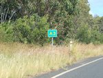
Trailblazer:
A3 trailblazer at Upper Yarraman, April 2011.
Image © Rob Tilley

Nanango-Tarong Rd:
ID sign at Cooyar at the junction with Nanango-Tarong Rd, April 2011.
Image © Rob Tilley

Palms Road:
Intersection directional sign at Palms Rd in Cooyar, April 2011.
Image © Rob Tilley

Advance Directional Sign:
AD sign approaching Munro St and McDougall St at Cooyar, April 2011.
Image © Rob Tilley

Advance Directional Sign:
AD sign approaching Saads Rd (SR68) at Wutul, April 2011.
Image © Rob Tilley

Intersection Directional Sign:
ID sign assembly the Saads Rd (SR68) junction in Wutul, April 2011.
Image © Rob Tilley
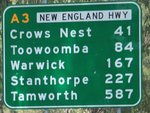
Distance Sign:
RD sign as New England Hwy (A3) leaves Wutul, April 2011.
Image © Rob Tilley

Advance Directional Sign:
AD sign at Pinelands with missing A3 shield approaching Haden-Crows Nest Rd, April 2011.
Image © Rob Tilley

Advance Directional Sign:
AD sign approaching William St in Crows Nest, April 2011.
Image © Rob Tilley
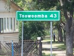
Distance Sign:
RD sign missing its A3 route number as New England Hwy leaves Crows Nest, April 2011.
Image © Rob Tilley

Advance Directional Sign:
AD sign at Pechey approaching Pechey-Maclagan Rd, April 2011.
Image © Rob Tilley
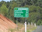
Distance Sign:
RD sign as New England Hwy (A3) leaves Pechey, April 2011.
Image © Rob Tilley

Advance Directional Sign:
AD sign at Hampton approaching Esk-Hampton Rd, April 2011.
Image © Rob Tilley

Intersection Directional Sign:
ID sign at Hampton facing Esk-Hampton Rd, showing original route numbers along New England Hwy, April 2011.
Image © Rob Tilley

Advance Directional Sign:
AD sign at Highfields approaching Highfields Rd, April 2011.
Image © Rob Tilley

Advance Directional Sign:
AD sign at Blue Mountain Heights approaching Murphys Ck Rd, April 2011.
Image © Rob Tilley

Murphys Creek Road:
Corner of New England Hwy (A3) and Murphys Ck Rd at Blue Mountain Heights, April 2011.
Image © Rob Tilley
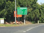
Distance Sign:
RD sign as New England Hwy (A3) leaves Blue Mtn Heights, April 2011.
Image © Rob Tilley
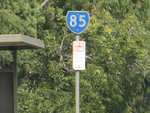
Trailblazer:
Old trailblazer from before the introduction of alphanumeric route numbering, North Toowoomba, April 2011.
Image © Rob Tilley

Advance Directional Sign:
AD sign missing the A3 route number at Toowoomba approaching Ruthven St, April 2011. A3 veers left at this junction along what is signposted as Chalk Dr.
Image © Rob Tilley

Ruthven Street:
New England Hwy (A3) (Chalk Dr) and Ruthven St split in Toowoomba, April 2011.
Image © Rob Tilley
1 QLD Government, Department of Transport and Main Roads, The State Road Network of Queensland map, 30 June 2022.


