Road Photos & Information: New South Wales
| B72 |
|
Snowy Mountains Highway (B72) - Bega to Cooma |
Statistics:
- Length: 332 km (Bega to Cooma: 105 km)
- Northern Terminus: Princes Hwy (A1) at Stony Creek, north of Bega
- Southern Terminus: Hume Hwy (M31) at Mundarlo, northwest of Adelong
- Miscellaneous: Route is co-signed with Monaro Hwy (B23) between Steeple Flat near Nimmitabel and Cooma
- Suburbs, Towns & Localities Along Route: Bega, Numbugga, Bemboka, Nimmitabel and Cooma
Route Numbering:
- Former:

- Multiplexes: B23
- Road Authority Internal Classification: HW4 (Stony Creek near Bega to Nimmitabel and Cooma to Mundarlo near Adelong) & HW19 (Cooma to Steeple Flat) 1
General Information:
Snowy Mountains Highway is a route that connects the Southern Tablelands of New South Wales with the far south coast via the Great Dividing Range and Snowy Mountains. It's mostly a 2-lane undivided rural highway, passing through farmland, residential and commercial regions. Large tracts of the route pass through national parks and traverse very hilly and steep terrain.
The route links the Princes Hwy (A1), Monaro Hwy (B23) and Hume Hwy (M31). The highest town along the highway is Kiandra, at a height of 1400 metres. 2
Multiplexes along the route include:
- B23, between Steeple Flat near Nimmitabel and Cooma, for 43 km
History:
- 1936: Work commences on the bridge over Bemboka River at Morans Crossing. 3
- 1955: Monaro Highway between Tumut to Tathra renamed Snowy Mountains Highway. 4
- 13 July 1955: Snowy Mountains Highway between Tathra to Nimmitabel and then Cooma to Mundarlo proclaimed as State Highway No. 4. 5
- 1957: A proposal to raise the road height between the fifth and sixth mile posts east of Bega at Jellat Jellat gazetted. 6
- October 1958: Snowy Mountains Highway between Cooma and Nimmitabel declared Monaro Highway. 4
- 1960: Current alignment of Snowy Mountains Highway in the Stony Creek area near Bega opened to traffic. 6
- 1964: Construction commenced on the Hanson Creek deviation, 10 miles from Bega, eliminating a longer and winding stretch of road. 1 new bridge was included in the construction, eliminating 2 existing ones. Sealing of 2.5 miles of highway on the Cooma side of Nimmitabel completed a sealed route between Cooma and Nimmitabel. 7
- February 1965: Work started on a six-mile deviation on the Snowy Mountains Highway from Nimmitabel to the McLachlan River. The scope of works included a high level bridge constructed over the McLachlan River. The deviation eliminated a level crossing, two high level bridges and a railway underground by-pass. 8 Reconstruction and sealing of highway between Bega and Nimmitabel announced. 9
- July 1966: The then divisional engineer of the NSW Department of Main Roads, Mr J, Neeson, announced a new route would of the Snowy Mountains Highway would reduce road closures due to snow. The deviation started at Big Bog, on Brown Mountain in a westerly direction, skirting the southern side of Pole Hill, joining the existing highway a few miles south of Nimmitabel. The new road section ascended to an altitude of 3700 ft, 400 ft lower than the old highway. 10
- 1967: Stabilisation work on sections of Kosciusko Road and the Snowy Mountains Highway near Kiandra. Sections of the road were damaged by erosion. The cost of the work was estimated at $530 000. 11
- April 1980: Tenders invited for the construction of a new bridge over Nunnock River, 41 km west of Bega. 12
- 1980s: A deviation of the route in the Nunnock River area at the base of Brown Mountain. 13
- 2003: Replacement of the bridge over and Butlers Creek, 18 km west of Bega. 14
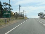 |
Reassurance Directional Sign:
Distance sign as Snowy Mtns Hwy (B72) leaves Cooma, October 2013.
Image © Paul Rands
|
 |
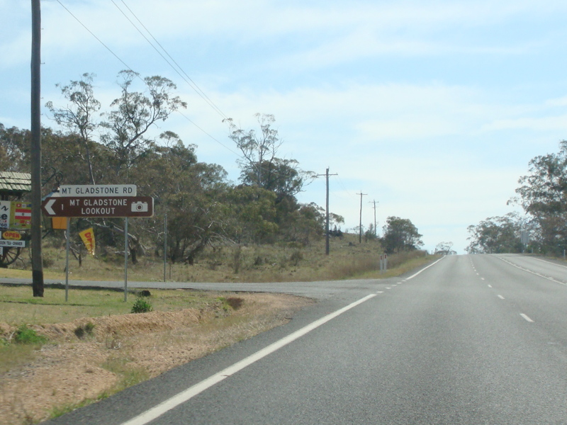
Mount Gladstone Road:
Corner of Mt Gladstone Rd and Snowy Mtns Hwy (B72) at Cooma, October 2013.
Image © Paul Rands
|
| Click here for the continuation of Snowy Mountains Highway (B72) between Cooma and Talbingo |
1 Roads and Traffic Authority, Schedule of Classified Roads (and unclassified Regional Roads), 20 February 2009
2 Department of Main Roads, Main Roads of New South Wales, undated brochure
3 State Library of NSW, Manuscripts, Oral History & Pictures, Bridge construction over Bemboka River at Morans Crossing
4 Canberra Times, Page 3, 21 October 1958
5 Government Gazette of the State of NSW, Issue 99, Page 2645, 9 September 1955
6 Government Gazette of NSW, Issue 171, Page 4278, 27 December 1957
6 Department of Main Roads, The Roadmakers, A History of Main Roads in New South Wales, ISBN 0 7240 0439 4, page 218
7 Canberra Times, Page 11, 1 September 1964
8 Canberra Times, Page 12, 15 February 1965
9 Canberra Times, Page 26, 18 February 1965
10 Canberra Times, Page 20, 7 July 1966
11 Canberra Times, Page 10, 8 February 1967
12 Canberra Times, Page 3, 20 April 1980
13 Sam Laybut (OzRoads)
14 Roads & Traffic Authority, Road activity update - Southern NSW, May 2003
Last updated: 22:37:22 12/3/2016.
This site © Paul Rands. All rights reserved. Some portions © (copyright) by their respective and credited owners. Permission must be obtained before using any images from this site. For details, please email by clicking here.