Road Photos & Information: International: New Zealand

|
|
State Highway 6 |
Statistics:
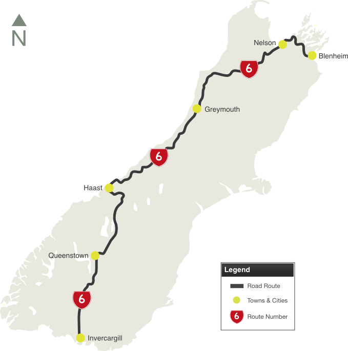
- Length: 1162 km
- Northern Terminus: SH1 at Blenheim
- Southern Terminus: SH at Invercargill
- Miscellaneous: Roads that form the route: Nelson Street, Middle Renwick Road, Blenheim Street, High Street, Jacks Road, Main Road, Hira Road, Wakapuaka Road, Atawhai Drive, Queen Elizabeth II Drive, Haven Road, Wakefield Quay, Rocks Road, Tahunanui Drive, Annesbrook Drive, Whakatu Drive, Richmond Deviation, Gladstone Road, Lightband Road, Brightwater Deviation, Whitby Road, Clifford Road, Wakefield-Kohatu Highway, Kohatu-Kawatiri Highway, Kawatiri-Murchison Highway, Waller Street, Four Rivers Highway, Upper Buller Gorge Road, Lower Buller Gorge Road, Camp Street, Coast Road, Stewart Street, Seven Mile Road, Cobden Bridge, Smith Street, Whall Street, Tainui Street, Main South Road, Taramakau Highway, Kumara Junction Highway, Fitzherbert Street, Ruatapu Road, Ruatapu-Ross Road, Aylmer Street, Moorhouse Street, Harihari Highway, Whataroa Highway, Franz Josef Highway, Fox Glacier Highway, Haast Highway, Haast Pass-Makarora Road, Makarora-Lake Hawea Road, Lake Hawea-Albert Town Road, Wanaka-Luggate Highway, Luggate-Cromwell Road, Kawarau Gorge Road, Gibbston Highway, Frankton-Ladies Mile Highway, Kawarau Road, Kingston Road, Kingston-Garston Highway, Garston-Athol Highway, Athol-Five Rivers Highway, Five Rivers-Lumsden Highway, Lumsden-Dipton Highway, Dipton-Winton Highway, Great North Road, Winton-Lorneville Highway, North Road and Dee Street
- Suburbs, Towns & Localities Along Route: Blenheim, Nelson, Westport, Greymouth, Hokitika, Wanaka, Queenstown and Invercargill
Route Numbering:
- Current:

- Former:


- Multiplexes:


General Information:
Located on the south island, SH6 is the longest single-island State Highway in New Zealand.
For most of its length SH6 is a two-lane single carriageway, except for a small section of dual carriageway in Invercargill, and passing lanes in Invercargill and Nelson.
The route features Hawk's Crag, which is a single-lane half tunnel blasted out of solid rock at Buller Gorge, the Taramakau River Bridge, which is a combined road and rail bridge, and also the longest single-lane bridge in NZ, the Haast River Bridge, which is 750 metres in length and features 2 passing bays.
Multiplexes along the route include:
- SH94, for 2 km, at Lumsden
- SH96, for 2 km, at Winton
- Southern Scenic Route, for 86 km between Frankton and Five Rivers, and also for 8 km between Lorneville and Invercargill
History:
- 1866: The first road around Nevis Bluff was constructed.
- 1869: Construction of Hawk's Crag tunnel at Buller Gorge.
- 2003: SH6 shifted to Whakatu Drive in Nelson to bypass residential areas. 1

 |
Advance Direction Sign:
AD sign approaching Hutchison St, Blenheim, September 2016.
Image © Dean Sherry
|
 |
Omoto Road:
Corner of Whall St (SH6), Smith St (SH6) and Omoto Rd (SH7) at Greymouth, September 2016. SH6 turns right at this location.
Image © Dean Sherry |
1 NZ Gazette, Revoking Sections of State Highway and Declaring New Sections of State Highway, 11 December 2003.
Last updated: 29-Jul-2020 0:52
This site © Paul Rands. All rights reserved. Some portions © (copyright) by their respective and credited owners. Permission must be obtained before using any images from this site. For details, please email by clicking here.


