Road Photos & Information: International: New Zealand
 |
|
State Highway 1 |
Statistics:
- Length: 2047 km (North Island: 1106 km) (South Island: 941 km)
- Northern Terminus:
- North Island: Cape Rēinga, 900 m southeast of Cape Rēinga Lighthouse, Northland
- South Island: Auckland St and London Quay, Picton
- Southern Terminus:
- North Island: Broadway and Stewart Duff Dr, Miramar
- South Island: Stirling Point, Bluff
- Miscellaneous: SH1 is split in two between the north and south islands
- North Island roads that form the route: Cape Rēinga Road, Far North Road, North Road, Matthews Avenue, South Road, Great North Road, Kamo Bypass, Western hills Drive, Otaika Road, Waipu Bypass, Rodney Street, Brown Road, Auckland Road, Northern Gateway Toll Road, Auckland-Waiwera Motorway, Northern Motorway, Southern Motorway, Waikato Expressway, Great South road, Gordonton Road, Avalon Drive, Avalon Drive Bypass, Lincoln Street, Greenwood Street, Kahikatea Drive, Lorne Street, Normandy Avenue, Cobham Drive, Cambridge Road, Tirau Road, Main Road, Tirau Street, Taupo Street, Swanston Street, Taupo Bypass, Mataroa Road, Hautapu Street, Mangawharariki Road, Milne Street, High Street, Bridge Street, Dundas Road, Wellington Road, Russell Street, Johnston Street, Levin Road, The Avenue, Oxford Street, Main Highway, Main Road North, Amohia Street, Main Road South, St Andrews Road, Mana Esplanade, Johnsonville Porirua Motorway, Centennial Highway, Wellington Urban Motorway, Vivian Street, Wellington Inner City Bypass, Kent Terrace, Sussex Street, Rugby Street, Ellice Street, Dufferin Street, Paterson Street, Taurima Street, Ruahine Street & Calabar Road
- South Island roads that form the route: Auckland Street, Wairau Road, Nelson Square, Grove Road, Sinclair Street, Main Street, Mills Street, Kekerengu Road, Kincaid Road, Athelney Road, Beach Road, Churchill Street, Kaikoura South Road, Hundalee Road, Parnassus Road, Hall Street, Domett Road, Greta Road, Omihi Road, Glasnevin Road, Carters Road, Ashworths Road, Main North Road, Christchurch Northern Motorway, Johns Road, Russley Road, Masham Road, Carmen Road, Main South Road, Rakaia Highway, Hinds Highway, West Street, Rangitata Highway, Orari-Rangitata Highway, Temuka-Orari Highway, Timaru-Temuka Highway, Hilton Highway, Evans Street, Theodosia Street, Craigie Avenue, King Street, Timaru-Pareora Highway, Waimate Highway, Glenavy-Hilderthorpe Road, Hilderthorpe-Pukeuri Road, Pukeuri-Oamaru Road, Thames Street, Severn Street, Wansbeck Street, Oamaru-Alma Road, Alma-Moheno Road, Maheno-Herbert Road, Herbert-Hampden Road, Hampden-Palmerston Road, Ronaldsay Street, Palmerston-Waikouaiti Road, Waikouaiti-Waitati Road, Main Road, Dunedin Northern Motorway, Cumberland Street, Great King Street, Gowland Street, Malcolm Street, Castle Street, Crawford Street, Andersons Bay Road, Caversham Bypass, Dunedin Southern Motorway, Taieri Plains Highway, Waihola Highway, Union Street, Milton Highway, Clinton Highway, Waipahi Highway, Gore Mataura Highway, Pioneer Highway, Edendale-Woodlands Highway, Woodlands-Invercargill Highway, Tay Street, Clyde Street, Bluff Highway, Ocean Beach Road, Blackwater Street, Gore Street, Marine Parade and Ward Parade
- Suburbs, Towns & Localities Along Route:
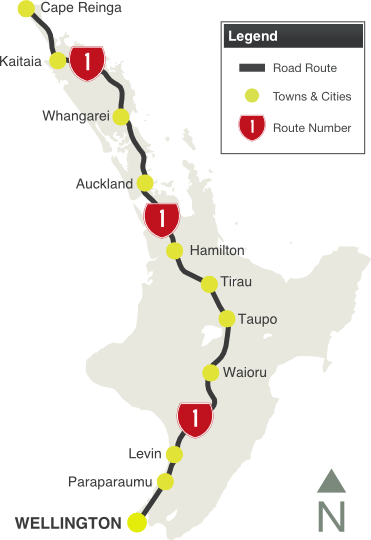
- North Island: Cape Rēinga, Whāngārei, North Shore, Auckland, Manukau, Hamilton, Taupo, Porirua and Wellington
- South Island: Picton, Blenheim, Kaikoura, Christchurch, Ashburton, Timaru, Oamaru, Dunedin, Gore, Invercargill and Bluff
Route Numbering:
General Information:
State Highway 1 is the main route throughout New Zealand, covering both the north and south islands.
The route is a mix of 2-laned rural highway, multi-laned urban arterial road, expressway and motorway standards. It passes through rural, commercial and industrial zones as well as through forested areas. The route is paved the entire length. A 7km section of the route is tolled (Northern Gateway Toll Road). 1
Multiplexes along the route include:
- SH3 for 6 km between Bulls and Sanson
- SH5 for 9 km between Wairakei and Maunganamu
- SH15 for 21 km between Otaika and Ruakaka
- SH30 for 5 km at Kinleith
- Twin Coast Discovery Highway for 8 km between Awanui and Kaitaia, for 92 km between Kawakawa and Waipu and for 20 km between Brynderwyn and Puhoi 2
- Thermal Explorer Highway for 179 km between Auckland and Tirau and for 11 km between Wairakei and Taupo 2
- Volcanic Loop Highway for 112 km between Taupo and Waioru 2
- Classic New Zealand Wine Trail for 28 km between Picton and Blenheim
- Alpine Pacific Triangle for 128 km between Kowhai and Amberley
- Southern Scenic Route for 41 km between Waihola and Balclutha and for 1 km in the Invercargill CBD
History:
North Island:
- 30 May 1959: The Auckland Harbour Bridge across the Waitemata Harbour, opened to traffic. Before it opened, the only way passenger vehicles could cross the harbour was by ferry. Cars and taxis were tolled 25¢), motorcycles 15¢, buses 50¢ and 40¢ for commercial vehicles. 3
- 1966-1969: Clip-on lanes were added to the Auckland Harbour Bridge at a cost of $7.4 million, doubling the number of lanes from four to eight to increase capacity and ease congestion. 3
- 31 March 1984: Tolls were officially abolished on Auckland Harbour Bridge. 3
- 1990: A moveable lane barrier system that includes a barrier and two machines is installed on the Auckland Habour Bridge to prevent head-on collisions and manage traffic flows in the ‘tidal’ morning and evening peak system. 3
- August 2008: A two and a half year project to strengthen the Auckland Harbour Bridge’s clip-on lanes started. 3
- 25 January 2009: Northern Gateway Toll Road opened to traffic. The 7.5km route extends the Northern Motorway from the Orewa turnoff to Puhoi, bypassing the seaside townships of Orewa, Hatfield's Beach, Waiwera and the Wenderholm Regional Park. The toll road features Johnstone’s Hill Twin Tunnels, which are 15 metres apart, 380 metres long, 12 metres wide and 9 metres high. They were built to carry two lanes each, plus a shoulder and an emergency pathway. 4
- 4 September 2011: The 1.3 km extention of Kamo Bypass in Whāngārei was officially opened. 5
- 1 October 2012: Widening works commence on SH1 (also known as Western Hills Drive) in central Whāngārei. 6
- 2015: Widening and realignment work begins on SH1 near Akerama Rd, near Hukerenui, 35km north of Whāngārei. 7
- November 2014: Work starts on adding an additional northbound lane from Ellerslie-Panmure Hwy on ramp to after the main highway overbridge. 8
- August 2015: Work commences on the 27km Transmission Gully Motorway between the Kapiti Coast and Wellington. 9
- 28 August 2015: Work commenced on the Huntly section of the Waikato Expressway. 10
- 27 October 2015: Work on safety improvements on State Highway 1 on the Brynderwyn Hill south of Whāngārei. It includes widening the road, removing tight corners and installing a wire rope barrier to separate north and south bound traffic. 11
- 16 December 2015: Completion of the 16km Cambridge section of the Waikato Expressway, starting south of the Tamahere interchange and ending around 2.5km south of Cambridge. 12
South Island:
- 1912: The Opawa River Bridge, between Picton and Blenheim on the northern edge of Blenheim, was designed. 13
- 1917: The Opawa River Bridge opened to traffic. The bridge is 170m long. 13
- 1932: Construction of the Dashwood Overbridge between Blenheim and Seddon. 14
- 2013: Completion of widening to 4 lanes between Russley Road from Avonhead Road to Yaldhurst Road. 15
- 20 December 2013: Johns Road, from Sawyers Arms Road to Harewood Road, opened to four lanes of traffic. 16
- 2014: Completion of widening to 4 lanes of Masham and Carmen Roads between Yaldhurst Road and Waterloo Road. 17
- March 2015: Work commenced on the upgrade of Johns Road (SH1), between The Groynes and Sawyers Arms Road. 18
- 13 May 2015: Work commences on the construction of the Western Belfast Bypass. 19
Click here for photos of the former SH1 alignment at Taupo
 |
 |
| |
| |
 |
Advance Direction Sign:
AD sign at Epsom approaching Gillies Av (UR12), February 2006.
Image © Paul Mech |
|
 |
Intersection Direction Sign:
ID sign at the intersection with Shag Point Rd at Shag Point, January 2012.
Image © Chris Reardon
|
 |
Advance Direction Signs:
AD signs at Epsom approaching Gillies Av (UR12), February 2006.
Image © Paul Mech |
|
 |
Advance Direction Sign:
AD sign at Hamilton East approaching Grey St (UR6), February 2006.
Image © Paul Mech |
 |
Trailblazer:
SH1 trailblazer at Remuera, February 2006.
Image © Paul Mech |
|
 |
Advance Direction Sign:
AD sign at Hamiilton approaching Ohaupo Rd (SH3), February 2006.
Image © Paul Mech |
 |
Advance Direction Sign:
AD sign at Remuera approaching Omahu Rd and Green Lane East (UR9), February 2006.
Image © Paul Mech |
|
 |
Confirmation Direction Sign:
Distance sign at Wellsford, April 2015.
Image © John Tokaji
|
 |
Confirmation Direction Sign:
Distance sign for next 3 exits at Remuera, February 2006.
Image © Paul Mech |
|
 |
Confirmation Direction Sign:
Distance sign at Wellsford, April 2015.
Image © John Tokaji
|
 |
Advance Direction Sign:
AD sign on the Te Iririrangi Dr overpass for the Redoubt Rd interchange, February 2006. Since this photo was taken, SH20 has been shifted to a new alignment.
Image © Paul Mech |
|
 |
Intersection Direction Sign:
ID sign at the junction with Puna Rere Dr at Whāngārei, April 2015.
Image © John Tokaji
|
 |
Confirmation Direction Sign:
Distance sign at Papakura, February 2006.
Image © Paul Mech |
|
|
|
 |
Confirmation Direction Sign:
Distance sign at Ohinewai, February 2006.
Image © Paul Mech |
|
|
|
 |
Old Advance Direction Sign:
Old style AD sign using older UK style fonts on Victoria St in Hamilton, approaching Bridge St and Tisdale St, February 2006.
Image © Paul Mech |
|
|
|
 |
Intersection Direction Sign:
ID sign on the roundabout with Morrinsville Rd (SH26) at Hillcrest, February 2006.
Image © Paul Mech |
|
|
|
 |
Confirmation Direction Sign:
Distance sign at Tamahere, February 2006.
Image © Paul Mech |
|
|
|
 |
Confirmation Direction Sign:
Distance sign at Raumati Beach, September 2016.
Image © Dean Sherry |
|
|
|
1 New Zealand Transport Agency, Roads & Rail, Toll Roads, Where The Toll Roads Are
2 Explore Central North Island, Map
3 NZTA, State highway projects, Auckland Harbour Bridge, History
4 Tapeka Del Mar, Northern Gateway Toll Road
5 NZTA, Media Release, NZTA's Kamo bypass opening boosts Rugby World Cup links, 4 September 2011
6 NZTA, Media Releases, NZTA to start next stage of Whāngārei's SH1 improvements
7 NZTA, State highway projects, SH1 Akerama Improvements
8 NZTA, State highway projects, SH1 Ellerslie Widening Project
9 NZTA, Transmission Gully Project, Project News http://www.tg.co.nz/projectnews.html
10 NZTA, Media Releases, Waikato Expressway surging ahead with start of Huntly section, 28 August 2015
11 NZTA, Media Releases, Safety improvements at Brynderwyns ramping up
12 NZTA: State highway projects, Waikato Expressway Cambridge
13 NZTA, The Opawa Bridge Replacement
14 NZTA, Dashwood Rail Overbridge Replacment, Project Update 2, November 2013
15 NZTA, State highway projects, Christchurch Motorways, Christchurch Western Corridor, SH1 Russley Road from Avonhead Road to Yaldhurst Road (Completed)
16 NZTA, Media Releases, Second stage of Western Corridor upgrade opens
17 NZTA, State highway projects, Christchurch Motorways, Christchurch Western Corridor, SH1 Masham and Carmen Roads (Completed)
18 NZTA, Media Releases, Johns Road Upgrade: The Groynes to Sawyers Arms Road, Progress Bulletin 1, March 2015
19 NZTA, Media Releases, Last section of Western Corridor underway, 13 May 2015
Last updated: 02-Feb-2017 10:39
This site © Paul Rands. All rights reserved. Some portions © (copyright) by their respective and credited owners. Permission must be obtained before using any images from this site. For details, please email by clicking here.


