Road Photos & Information: Western Australia
Barrack Street, Beaufort Street, Broun Avenue, Walter Road East and Beechboro Road North (State Route 53)
Former Alignment
Statistics:
- Length:
- 16 km
- Termini:
- Northern: Tonkin Hwy (SR4) and Hepburn Av (SR82), Whiteman
- Southern: Barrack St (SR5) and The Esplanade (SR5), Perth
- Suburbs, Towns & Localities Along Route:
- Perth, Highgate, Mount Lawley, Inglewood, Bedford, Morley, Embleton, Beechboro, Bennett Springs and Whiteman
Route Numbering:
- Former: 53
- XX
General Information:
State Route 53 connects the Perth CBD with the city' northeastern suburbs.
The route services some of Perth's older suburbs as well as suburbs built during the mid to late 20th century. The route takes in residential, commercial and light industrial areas and also bushland reservations at its northern end.
Prior to 2013 1, State Route 53 utilised Barrack Street and William Street as a one way pair. The William Street section featured the Horseshoe Bridge which was constructed in 1903 adjacent to the Perth railway station. The bridge was built as an attempt to reduce train-induced traffic congestion in William Street. The bridge name is derived from its shape: a horseshoe. 2 The removal of the one way pair was part of the Perth CityLink rail upgrade to connect Perth's CBD with Northbridge. 3
It's a major road in the inner north-eastern suburbs of Perth, linking the Morley area to Perth's CBD. For most of its length, it is a single-carriageway, two-way road with two lanes in each direction, but between Wellington Street and Brisbane Street, it is a one-way street (being a continuation of Barrack Street), with southbound traffic being directed along Brisbane Street onto William Street. It runs from Perth to Bedford, meeting Broun Avenue at Grand Promenade. Single carriageway of 2 lanes in each direction.
This segment of SR53 is both single and dual carriageway consisting of 4 lanes, it starts at Grand Promenade and makes its way northeast through Bedford, Morley and Embleton.
Beechboro Road is a north-south road connects Morley and Bayswater with Beechboro, Ballajura, Cullababardee, Whiteman and Lexia. Until the opening of the Tonkin Highway at Embleton, on 11 July 1984 5, Beechboro Road was one of northeastern Perth's most important routes.
History:
- 4 March 1973: In the Perth CBD, William Street was converted to one way traffic southbound, Barrack Street to one way traffic northbound. 4
- July 1984: Tonkin Highway severs Beechboro Road into Beechboro Road South and Beechboro Road North at Embleton. 5
- 2013: The William Street and Barrack Street one way pair reverted to two way operation. 1 3
This page concentrates on the former alignment between Perth and Whiteman
Perth to Whiteman
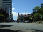
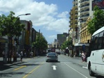
Cnr Barrack Street & The Esplanade:
Looking northeast in Perth CBD on Barrack Street. February 2008. Note the clock tower in the distance, this is the Perth Town Hall, situated on the corner of Hay and Barrack streets, it's the only convict-built town hall in Australia. Designed by Richard Roach Jewell and James Manning the hall was built by convicts and free men between 1868 and 1870. The foundation stone for Perth Town Hall was laid on the 24th of May 1867 by Governor Hampton. 2
Image © Paul Rands
2 City of Perth.
3 ACO Access, Barrack Street, Perth, WA.
4 Australian Transport Discussion Board, 3 March 1973, the last day before William St. went "one way", 26 June 2009.
5 WA Government, Main Roads Western Australia.

