Road Photos & Information: Victoria
Bendigo-Maldon Road, Bridgewater-Maldon Road, Maldon-Newstead Road, Pyrenees Highway, Daylesford-Newstead Road and Creswick-Newstead Road (C283)
Statistics:
- Length:
- 82 km
- Termini:
- Northern: Calder Alternative Hwy (A790), Lockwood South
- Southern: Clunes-Creswick Road (C291) and Webb St (unnumbered), Creswick
- Suburbs, Towns & Localities Along Route:
- Lockwood South, Porcupine Flat, Maldon, Hilldene, Welshmans Reef, Newstead, Sandon, Eberys, Campbelltown, Smeaton, Allendale, Broomfield and Creswick
Route Numbering:
- Current: C283
- Multiplexed with: B180 C282
- Road Authority Internal Classification: 1
- 5154 (Newstead to Creswick)
- 5202 (Lockwood South to Maldon)
- 5203 (Maldon)
- 5206 (Maldon to Newstead)
- 5212 (Newstead)
- 6740 (Newstead)
General Information:
C283 is a rural route which acts as an alternative north-south route between the greater Bendigo and greater Ballarat areas, connecting several highways.
Multiplexes along the route include:
- B180, for 600 m, Newstead.
- C282, for 2 km, Maldon.
Lockwood South to Creswick
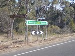
Intersection Directional Sign:
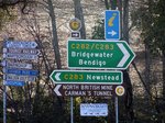
ID sign at the junction Maldon-Castlemaine Rd (C282) in Maldon, April 2006. Note the yellow 'km' plate on the fingerboards on the left of shot. These were installed on most signs with distances when the metric signs were first installed in the 1970s.
Image © Rob Tilley
1 VIC Government, VicRoads, Road Maintenance Plan 2020-2021, 07 December 2020.
