Road Photos & Information: Tasmania
Kindred Road (B16)
Statistics:
- Length:
- 14 km
- Termini:
- Northern: Forth Rd (B19), Forth
- Southern: Castra Rd (B15) at Sprent
- Suburbs, Towns & Localities Along Route:
- Forth, Kindred, Moreton and Sprent
Route Numbering:
- Current: B16
General Information:
B16 is a link road between Castra Rd (B15) and Forth Rd (B19) in the hinterland behind Ulverstone on the north west coast of Tasmania. It is the responsibility of Central Coast Council.
The current route was not the one originally planned in 1980 - a 1981 Route Direction Progress Map shows that B16 originally ran along Kindred Rd from Forth to Swamp Rd and then through to Castra Rd. The current alignment between Swamp Rd and Castra Rd was designated as C130. It is not known at what stage the current alignment was approved.
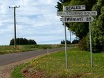
There are no intersecting numbered routes. Geales Rd does provide a local connecting route through to the C132 at Wilmot and carries local tourist route signs at the Wilmot end.
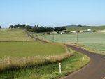
B16 is a sealed route throughout and passes through rich agricultural land, mainly market gardens.


