Statistics:
- Length:
- 415 km
- Termini:
- Northern: Bass Hwy (A2), Somerset
- Southern: Brooker Hwy (NH1) and Midland Hwy (NH1), Granton
- Suburbs, Towns & Localities Along Route:
- Granton, New Norfolk, Lawitta, Hayes, Rosegarland, Gretna, Hamilton, Ouse, Wayatinah, Tarraleah, Bradys Lake, Derwent Bridge, Gormanston, Queenstown, Zeehan, Rosebry, Tullah, Parrawe, Oonah, Henrietta, Yolla, Elliott and Somerset
Route Numbering:
- Current: A10
- Former: 8
- Road Authority Internal Classification: 1
- A0197 (Granton to Queenstown)
- A0472 (Queenstown to Zeehan)
- A0485 (Zeehan to Somerset)
General Information:
Servicing Tasmania's rugged west coast, the route connects several small communities with the ports on the north coast and the state capital, Hobart.
The route is mostly of rural highway standard and twists its way through several mountain passes, and through world heritage wilderness zones and features spectacular scenery along its entire length.
History:
- 1932: The Lyell Highway, constructed as a link between the mining town of Queenstown and Hobart.
- 1964: Murchison Highway opened.
- 2003: Improvements at the Molesworth junction on the Lyell Highway and also at the junction of the Lyell Highway and Boyer Secondary Road. 3

Advance Directional Sign:
AD sign on Midland Hwy (NH1) at Granton, approaching Brooker Hwy (NH1) and Lyell Hwy (A10), May 2007.
Image © Peter Renshaw

Reassurance Directional Sign:
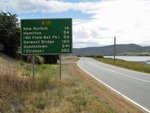
Distance sign at Granton, 2008.
Image © Jamie Scuglia

Ouse Town Centre:
Lyell Hwy (A10) as it passes through the Ouse town centre, March 2016.
Image © Garry Coxhead

Advance Directional Sign:
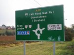
AD sign at New Norfolk approaching Pioneer Av and Turriff Lodge Dr, July 2007.
Image © Peter Renshaw

Advance Directional Sign:
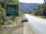
AD sign on Zeehan Hwy (A10) near Leslie Ck, approaching the B27 section of Zeehan Hwy at Zeehan, March 2016.
Image © Garry Coxhead

Entering Linda:
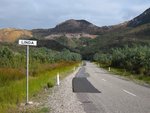
Lyell Hwy (A10) as it enters the locality of Linda, 2008.
Image © Jamie Scuglia

Advance Directional Sign:
AD sign on Murchison Hwy (A10) approaching Anthony Rd (B28) at Tullah, 2008.
Image © Jamie Scuglia

Intersection Directional Sign:
ID sign assembly facing Farrell St in Tullah, March 2016.
Image © Garry Coxhead

Intersection Directional Sign:
ID sign assembly facing Waratah Rd (B23) at Guildford, March 2016.
Image © Garry Coxhead

Intersection Directional Sign:
ID sign assembly facing Mount Hicks Rd (B26) at Yolla, March 2016.
Image © Garry Coxhead

Intersection Directional Sign:
ID sign facing eastbound traffic Bass Highway (A2) at its junction with Murchison Hwy (A10) in Somerset. October 2007.
Image © Peter Renshaw

Advance Directional Sign:
AD sign on Murchison Hwy (A10) approaching Anthony Rd (B28) at Tullah, 2008.
Image © Jamie Scuglia

Ouse Town Centre:
Lyell Hwy (A10) as it passes through the Ouse town centre, March 2016.
Image © Garry Coxhead

Advance Directional Sign:
AD sign on Lyell Hwy (A10) at Gretna approaching Gordon River Rd (B61), March 2016.
Image © Garry Coxhead

Entering New Norfolk:
Lyell Hwy (A10) as it enters the town of New Norfolk, March 2016.
Image © Garry Coxhead

Advance Directional Sign:
AD sign on Lyell Hwy (A10) approaching Brooker Hwy (NH1) and Midland Hwy (NH1) at Granton, 2008.
Image © Jamie Scuglia

Southern Terminus:
Lyell Hwy (A10) at its southern terminus, Brooker Hwy (NH1) and Midland Hwy (NH1) at Granton, March 2016.
Image © Garry Coxhead
1 TAS Government, Department of State Growth, State Roads, Asset Information, TRIPS: Tasmanian Road Information Positioning System, December 2020.
2 Planetware.
3 TAS Government, Department of Infrastructure, Energy and Resources.


