Statistics:
- Length:
- 207 km
- Termini:
- Northern: Augusta Hwy (A1) and Nelshaby Rd (George Corner), Bungama
- Southern: Yprke Hwy (B86), Minlaton
- Suburbs, Towns & Localities Along Route:
- Bungama, Coonamia, Solomontown, Port Pirie, Port Pirie South, Risdon Park South, Pirie East, Nurom, Wandearah East, Clements Gap, Mundoora, Port Broughton, Ward Hill, Alford, Wallaroo Plain, Wallaroo, Warburto, Paramatta, North Moonta, Moonta Mines, Kooroona, Agery, Weetulta, Mailtand, Yorke Valley, Urania, Wauraltee, Koolywurtie, Minlaton,
Route Numbering:
- Current: B89
- Road Authority Internal Classification: 1
- 03480 (Bungama to Port Pirie)
- 03483 (Port Pirie)
- 04386 (Port Pirie to Port Broughton)
- 03680 (Port Broughton to Alford)
- 04159 (Alford to Wallaroo)
- 04156 (Wallaroo)
- 04138 (Wallaroo to Moonta)
- 04126 (Moonta)
- 04127 (Moonto to Maitland)
- 04015 (Maitland to Minlaton)
General Information:
B89 is located on the Yorke Peninsula, on the eastern side of the Spencer Gulf in South Australia. The route is mostly rural highway standard, and services industrial, commercial, residential and farming areas, and links several port towns with the business hub of Port Pirie, which was South Australia's first proclaimed provincial city. 2
History:
- 2010: Proclamation of the Spencer Highway name, which linked several smaller roads to form the route. 3

Advance Directional Sign:
AD sign at Port Broughton on Bute Road approaching Spencer Highway (Bay Street) (B89). June 2010. Click or tap here for a photo of this location by Michael Greenslade from December 2003.
Image © Darrin Smith

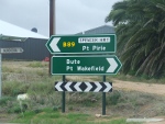
Advance Directional Sign:
AD sign at Port Broughton approaching Bute Rd, December 2003.
Image © Michael Greenslade

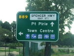
Intersection Directional Sign:
ID sign assembly at Port Broughton at the junction with Bute Road, facing Spencer Highway (Bay Street) (B89). June 2010.
Image © Darrin Smith

Advance Directional Sign:
Approaching the intersection of Warnertown Rd and Pt Germain Rd at Port Pirie. June 2007.
Image © Darrin Smith

Warnertown Road / Port Germain Road Intersection:
Corner of Warnertown Rd and Pt Germain Rd. B89 turns left here and eventually meets A1. June 2007.
Image © Darrin Smith

AD Sign:
Advance directional sign approaching Augusta Hwy (A1) and Nelshaby Road intersection at Bungama, June 2007.
Image © Darrin Smith

Augusta Hwy / Nelshaby Rd Intersection:
Corner of Augusta Highway (A1) and Nelshaby Road at Bungama, with the Flinders Ranges in the distance, June 2007.
Image © Darrin Smith

AD Sign:
Advance directional sign as you enter the Port Pirie area. corner of Main Street and Three Chain Road. December 2003.
Image © Michael Greenslade

Reassurance Directional Sign:
Distance sign with space for route number at Port Pirie South, December 2003.
Image © Michael Greenslade

NEW Advance Directional Sign:
AD sign approaching Magazine Rd and Cresco Rd at Wallaroo, January 2016.
Image © Michael Greenslade

NEW Reassurance Directional Sign:
Distance sign at Wallaroo, January 2016.
Image © Michael Greenslade

NEW Advance Directional Sign:
AD sign at Moonta approaching Military Rd and Ryan St, January 2016.
Image © Michael Greenslade

NEW Reassurance Directional Sign:
Distance sign at Moonta, January 2016.
Image © Michael Greenslade

NEW Entering Maitland:
Spencer Hwy (B89) entering the town of Maitland, January 2016.
Image © Michael Greenslade

NEW Advance Directional Sign:
AD sign approahing Centenary Av and Rogers Tce, Maitland, January 2016.
Image © Michael Greenslade

NEW Gardiner Terrace & Port Victoria Road:
Corner of Spencer Hwy (B89), Gardiner Tce and Port Victoria Rd, Maitland, January 2016.
Image © Michael Greenslade
1 SA Government, Location SA Map Viewer.
2 Port Pirie Regional Council.
3 Darrin Smith.


