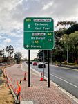
Road Photos & Information: South Australia
Fullarton Road, Maitland Street, Taylors Road, Old Belair Road, James Road, Upper Sturt Road and Mount Lofty Summit Road (B28)
Statistics:
- Length:
- 27 km
- Termini:
- Northern: North Tce (A11), Magill Rd (B27) and Baliol St, Kent Town
- Southern: Greenhill Rd (B26), Greenhill
- Suburbs, Towns & Localities Along Route:
- Kent Town, Norwood, Rose Park, Dulwich, Adelaide, Eastwood, Frewville, Fullarton, Parkside, Myrtle Bank, Highgate, Urrbrae, Netherby, Springfield, Mitcham, Belair, Hawthorndene, Upper Sturt, Crafers West, Crafers, Cleland, Summertown and Greenhill
Route Numbering:
- Current: B28
- Multiplexed with: R1
- Former: A21 1
- Road Authority Internal Classification:
- 06146 (Norwood to Springfield)
- 06303 (Crafers West to Greenhill
- 06443 (Springfield to Belair)
- 06445 (Belair)
- 06449 (Belair to Crafers West)
General Information:
B28 is an arterial route in Adelaide's eastern suburbs, linking the CBD with suburbs to the south and with the Adelaide Hills.
The route services mostly residential and commercial zones, and passes through several bushland areas including Belair National Park.
Multiplexes along the route include:
- R1, for 1 km, between Kensington Rd and Wakefield Rd, Rose Park and Greenhill Rd (R1 and B26), Dulwich.
History:
- 2022: Work commenced on upgrade works at the intersection of Glen Osmond Road and Fullarton Road. Work included widening of Fullarton Road to provide an additional (third) dedicated through traffic lane on each side of Fullarton Road through the intersection. Widening on Glen Osmond Road to provide an additional (second) dedicated right turn lane from Glen Osmond Road onto Fullarton Road for traffic to travel north. Removal of the tight turn lane on Fullarton Road into Glen Osmond Road heading towards the city (right turn movements prohibited at all times). Widening on Glen Osmond Road to provide a longer right turn lane for traffic turning onto Fullarton Road to travel southbound. Relocation and indenting of a bus stop on Glen Osmond Road east of the intersection. Installation of a sheltered right turn lane on Fullarton Road at the junction with Campbell Road. Installation of traffic signals at the junction of Glen Osmond Road and Main Avenue, which also incorporated a sheltered right turn lane from Glen Osmond Road. Realignment of Main Avenue to relocate the junction at Glen Osmond Road 50 metres southeast from its previous location. Removal of right turn movement out of Frewville Foodland and Arkaba Hotel. Relocation and upgrade of pedestrian signals on Glen Osmond Road. Installation of pedstrian signals on Fullarton Road (south of the intersection), opposite the Woolworths carpark, between Hone Street and Campbell Road. New pavement construction and surfacing, new and upgraded traffic signals, LED road lighting and new line marking and drainage. 2
Kent Town (Adelaide) to Greenhill
1 SA Government, Location SA Map Viewer.
2 SA Government, Department of Infrastructure and Transport, Road Projects, Glen Osmond Road and Fullarton Road Intersection Upgrade.
2 SA Government, Department of Infrastructure and Transport, Road Projects, Glen Osmond Road and Fullarton Road Intersection Upgrade.

