Statistics:
- Length:
- 64 km
- Termini:
- Eastern: Petrie Tce (SR10), Countess St (SR10), College Rd (SR10) and Kelvin Grove Rd (SR77), Kelvin Grove
- Western: Wivenhoe-Somerset Dam Rd (unnumbered), Dundas
- Suburbs, Towns & Localities Along Route:
- Dundas, England Creek, Mount Glorious, Banks Creek, Lake Manchester, Mount Nebo, Enoggera Reservoir, Jollys Lookout, The Gap, Ashgrove, Red Hill and Kelvin Grove
Route Numbering:
- Current: 31
- Multiplexed with: 8 9
- Road Authority Internal Classification: 1
- 4023 (Dundas to Banks Creek)
General Information:
State Route 31 is route that links the Brisbane CBD with the inner western suburbs as well as the Brisbane Forest Park.
The route is a mix of divided and undivided roadway passing mostly through residential and bushland areas, with some commercial areas along it as well.
Multiplexes along the route include:
- Tourist Drive 8, for 28 km, between The Gap and Mount Nebo.
- Tourist Drive 9, for 6 km, between Banks Creek and Mt Glorious.
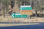
Intersection Directional Sign:
ID sign at the corner of Northbrook Pkwy (SR31 / TD9) and Wivenhoe-Somerset Dam Rd at Dundas, August 2018.
Image © Rob Tilley

Intersection Directional Sign:
ID sign at Mt Glorious at the Mt Glorious Rd (TD9) junction, August 2018.
Image © Rob Tilley
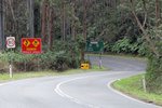
Reassurance Directional Sign:
Distance sign at Mt Glorious, August 2018.
Image © Rob Tilley
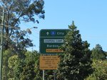
Advance Directional Sign:
AD sign on Waterworks Rd (SR31) approaching Coopers Camp Rd and Glory St (SR31) at Ashgrove, July 2011.
Image © Rob Tilley

Advance Directional Sign:
AD sign at Ashgrove near Elimatta Dr (Metroad 5) approaching Jubilee Tce (Metroad 5), March 2013.
Image © Paul Rands

Trailblazer:
SR31 trailblazer at Ashgrove, near Kadanga Rd, March 2013.
Image © Paul Rands

Advance Directional Sign:
AD sign at Ashgrove approaching Stewart Rd, March 2013. The Metroad 5 shield should be prefixed with 'To'.
Image © Paul Rands

Intersection Directional Sign:
AD style sign acting as an ID sign, facing Stewart Rd at Ashgrove, March 2013.
Image © Paul Rands

Advance Directional Sign:
AD sign at Ashgrove, approaching Ashgrove Av, March 2013.
Image © Paul Rands

Intersection Directional Sign:
AD style sign acting as an ID sign, facing Ashgrove Av at Ashgrove, March 2013.
Image © Paul Rands
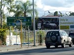
Advance Directional Sign:
AD sign on College Rd (SR10) approaching Countess St (SR10) and Musgrave Rd (SR31) at Brisbane, June 2009.
Image © Rob Tilley
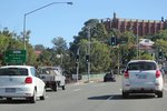
Hale Street:
Musgrave Rd (SR31) at the Hale St (M3) interchange at Red Hill, August 2018. Click or tap here for a photo of this location by Rob Tilley from June 2009.
Image © Rob Tilley
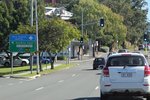
Advance Directional Sign:
AD sign on Musgrave Rd (SR31) at Red Hill at the Hale St (M3) interchange, August 2018.
Image © Rob Tilley
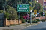
Advance Directional Sign:
AD sign at Ashgrove approaching Ashgrove Av, May 2018.
Image © Rob Tilley

Advance Directional Sign:
AD sign at Ashgrove approaching Stewart Rd, March 2013. The Metroad 5 shield should be prefixed with 'To'.
Image © Paul Rands
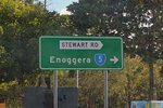
Intersection Directional Sign:
AD style sign being used as ID sign at the junction with Stewart Rd at Ashgrove, May 2018. The SR5 shield is an error.
Image © Rob Tilley

Reassurance Directional Sign:
Distance sign at Ashgrove, March 2013.
Image © Paul Rands

Trailblazer:
Trailblazer facing Coopers Camp Rd at Ashgrove where it meets Waterworks Rd, March 2013.
Image © Paul Rands

Intersection Directional Sign:
ID sign without route number at the junction with Coopers Camp Rd in Ashgrove, March 2013.
Image © Paul Rands
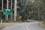
Reassurance Directional Sign:
Distance sign on Mt Glorious Rd (SR31 / TD9) at Mt Glorious, August 2018.
Image © Rob Tilley
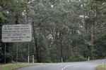
Steep Descent Sign:
Sign warning of steep descent and prohibition of certain vehicles, Mt Glorious, August 2018.
Image © Rob Tilley
1 QLD Government, Department of Transport and Main Roads, Metropolitan Road Region Map, November 2022.


