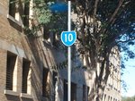
Road Photos & Information: Queensland
Montpellier Road, Campbell Street, Hamilton Place, Brookes Street, Gregory Terrace, College Road, Countess Street, Saul Street, Skew Street, Upper Roma Street, Petrie Terrace, Grey Street, Peel Street, Merrivale Street, Cordelia Street, Vulture Street, Stanley Street, Annerley Road, Ipswich Road, Waterton Street, Ekibin Street, Sexton Street, Toohey Road, Esher Street, Birdwood Road, Marshall Road, Holland Road, Boundary Road, Wiles Street, Ferguson Road, Oateson Skyline Drive, Kensington Avenue, Agnew Street, Bennetts Road, Wynnum Road and Riding Road (State Route 10) (Metropolitan Region)
Statistics:
- Length:
- 24 km
- Termini:
- Eastern: Oxford St (unnumbered), Lytton Rd (unnumbered) and Hawthorne Rd (unnumbered), Bulimba
- Western: Wickham St (SR25), Ann St (SR25), Breakfast Creek Rd (SR25) and Skyring Tce (unnumbered), Bowen Hills
- Suburbs, Towns & Localities Along Route:
- Newstead, Bowen Hills, Spring Hill, Petrie Terrace, Brisbane, South Brisbane, Dutton Park, Annerley, Tarragindi, Holland Park West, Holland Park, Camp Hill, Seven Hills, Norman Park, Morningside, Hawthorne, Balmoral and Bulimba
Route Numbering:
- Current: 10
- Multiplexed with: A7 23
General Information:
State Route 10 is a circuitous route in the inner suburbs of Brisbane. It takes in mostly residential and commercial areas, and passes through the central business district of the state capital, Brisbane.
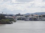
There are several features along the route, including 2 one way pairs in Brisbane and South Brisbane. Another prominent feature is the William Jolly Bridge.
The William Jolly Bridge is the sixth crossing of the Brisbane River in Brisbane. It is a concrete arch bridge and was opened to traffic on March 30, 1932 by Sir John Goodwin, the Governor of Queensland. The designing and supervising engineer was A.E. Harding Frew.
The William Jolly Bridge is shared by vehicular traffic, pedestrians and cyclists. It connects Grey Street in South Brisbane to Roma Street on the western edge of the central business district. The bridge was conceived as a bypass for motor traffic between the southern suburbs and western suburbs of Brisbane to avoid increasing traffic congestion on the Victoria Bridge and on downtown streets such as George Street and when it opened, the bridge was known simply as the Grey Street Bridge. It was renamed to the William Jolly Bridge on July 5, 1955 in memory of William Jolly, the first Lord Mayor of Greater Brisbane.
- State Route 23, for 140 m, Norman Park and Morningside.
- A7, for 450 m, Annerley.
History:
- 30 March 1932: Grey Street Bridge over Brisbane River opened to traffic by Sir John Goodwin, the Governor of Queensland. 1
- 5 July 1955: Grey Street Bridge renamed to William Jolly Bridge, the first Lord Mayor of Greater Brisbane. 1
Newstead to Bulimba
2 Best Bridge, Australia and Oceania, William Jolly Bridge.


