Road Photos & Information: Queensland
 |
|
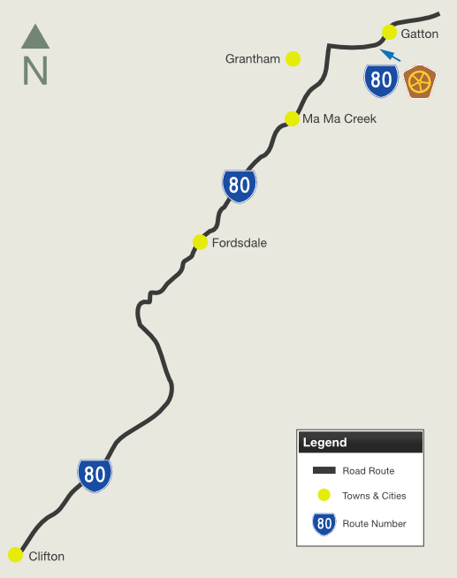
Gatton-Clifton Road, Gatton-Helidon Road, Western Drive, Railway Street, Spencer Street and Eastern Drive (State Route 80) |
Statistics:
- Length: 63 km
- Northern Terminus: Warrego Hwy (A2) & Gatton-Esk Rd at Gatton
- Southern Terminus: New England Hwy (A3) at Clifton
- Suburbs, Towns & Localities Along The Route: Gatton, Grantham, Ma Ma Creek, Fordsdale, Hirstglen, Pilton and Clifton
Route Numbering:
- Current:

- Former:


- Multiplexes:

- Road Authority Internal Classification: 313 (Clifton to Grantham) & 314 (Grantham to Gatton) 1
General Information:
State Route 80 is a rural route connecting the New England and Warrego Highways, west of Brisbane in the Lockyer Valley.
The route passes mostly through rural and bushland areas, however there are some commercial and residential properties along the route as well.
The Western Drive, Railway Street, Spencer Street and Eastern Drive section of the route was once part of the Warrego Highway.
Multiplexes along the route include:
- Cobb & Co Tourist Drive for 8 km, from Gatton to Grantham
History:
- 1985: Construction begins on Gatton Bypass. 2
- 1989: Gatton Bypass (current Warrego Hwy alignment) opens to traffic as a single carriageway route. 2
- 1994: Construction of overtaking lanes on Gatton Bypass. 2
- September 2002: Work begins on duplication of Gatton Bypass. 2
- October 2003: Gatton Bypass opens to traffic, a month early, despite delays from a contractor entering voluntary liquidation. 3
- November 2009: Work begins on replacement bridge over Ma Ma Creek on Gatton-Clifton Rd. The bridge is made up of three 16 metre-spans and is 8.6 metres wide. As part of the project, new approaches on either side of the bridge were also constructed to provide two, three metre-wide traffic lanes with one metre wide sealed shoulders. The bridge and approaches are on a new 520-metre-long alignment. 4
- October 2011: Work begins on upgrade of the intersection of Western Drive and Lake Apex Drive, Gatton. Works included installing a right-turn lane from Western Drive into Lake Apex Drive, installation of warning and guide signage and pavement markers, as well as the upgrade of line marking on all approaches. 5
- November 2011: Work commences on replacement bridge over Kings Creek on Gatton-Clifton Rd at Pilton. 6

 |
Intersection Directional Sign:
ID sign at Grantham at the junction with Grantham-Helidon Rd (Cobb & Co Tourist Drive), April 2011.
Image © Rob Tilley
|
 |
Advance Directional Sign:
AD sign in Gatton approaching Spencer St & Railway St, April 2011.
Image © Rob Tilley
|
 |
Intersection Directional Sign:
ID sign at the junction with Spencer St and Railway St in Gatton, April 2011. SR80 turns right at this junction.
Image © Rob Tilley
|
 |
Supplemental Advance Directional Sign:
Supplemental AD sign on Eastern Dr (SR80) at Gatton approaching Gatton-Laidley Rd (Cobb & Co Tourist Drive), April 2011.
Image © Rob Tilley
|
 |
Advance Directional Sign:
AD sign on Eastern Dr (SR80) at Gatton approaching Gatton-Laidley Rd (Cobb & Co Tourist Drive), April 2011.
Image © Rob Tilley
|
 |
Gatton-Laidley Road:
Corner of Eastern Dr (SR80) and Gatton-Laidley Rd at Gatton, April 2011.
Image © Rob Tilley
|
 |
Distance Sign:
RD sign on Eastern Dr (SR80) at Gatton, April 2011.
Image © Rob Tilley
|
 |
Advance Directional Sign:
Battered AD sign on Eastern Dr (SR80) approaching Warrego Hwy (A2) and Gatton-Esk Rd at Gatton, April 2011.
Image © Rob Tilley
|
 |
Warrego Highway & Gatton-Esk Road:
Intersection directional sign at the interchange with Warrego Hwy (A2) and Gatton-Esk Rd at Gatton, April 2011.
Image © Rob Tilley
|
 |
Warrego Highway & Gatton-Esk Road:
Intersection directional sign at the interchange with Warrego Hwy (A2) and Gatton-Esk Rd at Gatton, April 2011.
Image © Rob Tilley
|
 |
Advance Directional Sign:
AD sign within the interchange with Warrego Hwy (A2) and Gatton-Esk Rd at Gatton, April 2011.
Image © Rob Tilley
|
 |
Warrego Highway & Gatton-Esk Road:
Intersection directional sign at the interchange with Warrego Hwy (A2) and Gatton-Esk Rd at Gatton, April 2011.
Image © Rob Tilley
|
 |
Warrego Highway & Gatton-Esk Road:
Intersection directional sign at the interchange with Warrego Hwy (A2) and Gatton-Esk Rd at Gatton, April 2011.
Image © Rob Tilley
|
1 Transport and Main Roads, Queensland state-controlled roads and region maps, Metropolitan Region: west
2 Lachlan Sims
3 The Earthmover & Civil Contractor magazine, Gatton Bypass duplication opens one month early, November 2003.
4 Queensland Government, Ministerial Media Statements, New bridge spans Ma Ma Creek, 5 November 2009
5 Transport and Main Roads, Projects, Intersection safety improvement works Gatton
6 Queensland Government, Ministerial Media Statements, Work starts on $4.6m bridge for Kings Creek, 21 November 2011
Last updated: 17-Dec-2019 0:55
This
site ©
Paul Rands. All rights reserved. Some portions © (copyright) by their
respective and credited owners. Permission must be obtained before using
any images from this site. For details, please email by clicking
here.


