Road Photos & Information: Queensland
Port of Brisbane Motorway (State Route 42) (Decommissioned)
Statistics:
- Length:
- 4 km
- Termini:
- Eastern: Lytton Rd (SR24), Lytton
- Western: Gateway Mwy (M1), Hemmant
- Suburbs, Towns & Localities Along Route:
- Hemmant and Lytton
Route Numbering:
- Current: M4
- Former:42
General Information:
State Route 42 was a short super-2 motorway grade road linking the Gateway Mwy (M1) with Brisbane's eastern heavy industrial area near the Brisbane River and airport.
History:
- 2003: Port of Brisbane Motorway (SR42) opened to traffic. 1
- 2010: Upgrade of Lindum Rd (SR30) interchange at Hemmant. 2
- 2012: State Route 42 replaced by M4 route number.
Hemmant to Lytton
Lytton to Hemmant

Advance Directional Sign:
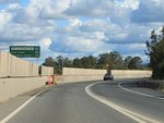
AD sign at Hemmant approaching Gateway Mwy (M1), July 2011. Click or tap here for a photo of this location by Michael Greenslade from May 2005.
Image © Rob Tilley
1 QLD Government, Department of Transport and Main Roads, PortConnect Project Overview.
2 QLD Government, Department of Transport and Main Roads, Projects, Intersection safety improvements for access to the Port of Brisbane.
2 QLD Government, Department of Transport and Main Roads, Projects, Intersection safety improvements for access to the Port of Brisbane.


