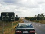
Road Photos & Information: Queensland
Capricorn Highway (National Route 66)
Statistics:
- Length:
- 576 km
- Termini:
- Eastern: Bruce Hwy (NH1), Fairy Bower
- Western: Landsborough Hwy (NH54 / NH71), Barcaldine
- Suburbs, Towns & Localities Along Route:
- Barcaldine, Jerico, Alpha, Anakie, Emerald, Comet, Blackwater, Bluff, Dingo, Duaringa, Gogango, Westwood, Wycarbah, Bushley, Stanwell, Kabra, Gracemere and Fairy Bower (Rockhampton)
Route Numbering:
- Current: A4
- Former: 66
- Multiplexed with: 55
- Road Authority Internal Classification:
- 16A (Duaringa to Rockhampton) 1
- 16B (Emerald to Duaringa) 1
- 16C (Alpha to Emerald) 1
- 16D (Barcaldine to Alpha) 2
General Information:
Capricorn Highway is an important route in the Queensland highway system, linking farming and mining interests of Central Queensland with the coast and Bruce Highway at Rockhampton.
Tracing the Tropic of Capricorn and crossing the Great Dividing Range, the route is rural highway standard, consisting mostly of 1 lane in each direction, and services residential, rural and industrial areas.
Multiplexes along the route include:
- National Route 55, for 1.5 km, Emerald.
History:
- 2004: NR66 replaced by A4 with the implementation of the Strategic Tourism Route Numbering scheme. 3
1 QLD Government, Department of Main Roads, The State Road Network of Queensland Map, Central Highlands District 15, August 2004.
2 QLD Government, Department of Main Roads, The State Road Network of Queensland Map, Central Western District 7, August 2004.
3 Michael Greenslade.
2 QLD Government, Department of Main Roads, The State Road Network of Queensland Map, Central Western District 7, August 2004.
3 Michael Greenslade.
