Road
Photos & Information: New South Wales
 |
|
Hume Highway & Great Western Highway (State Route 31) (Decommissioned) |
Statistics:
- Length: 32 km
- Eastern
Terminus: George Street, Regent Street & Harris Street, Ultimo
- Western
Terminus: Cumberland Highway & Hume Highway, Liverpool
- Miscellaneous: Also signposted as Liverpool Road and Parramatta Road
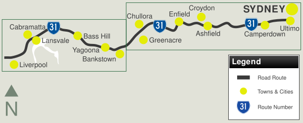
- Suburbs, Towns
& Localities Along The Route: Liverpool, Warwick Farm, Cabramatta, Canley Vale, Carramar, Lansvale, Lansdowne, Villawood, Bass Hill, Yagoona, Bankstown, Greenacre, Chullora, Strathfield, Strathfield South, Enfield, Burwood, Burwood Heights, Croydon, Ashfield, Summer Hill, Leichhardt, Petersham, Stanmore, Annandale, Camperdown, Chippendale and Ultimo
Route Numbering:
- Former:


- Road Authority
Internal Classification: HW2 (Hume Hwy) & HW5 (Great Western Hwy)
- Decommissioned: 2013
General Information:
State Route 31 is a main route in and out of Sydney's CBD to the city's southwestern suburbs. Formed by some of the earliest roads built in the colony, the route is generally multi-laned and passes through commercial, residential and industrial areas.
Features along the route include Remembrance Driveway, which commemorates fallen soldiers at war. Also along the route at the Woodville Rd junction, is the Meccano Set. It's an unusual overhead installation of traffic signals. Its nickname comes from the Meccano toy, which some people say the intersection resembles. Eastbound traffic also uses one of the oldest bridges still in use in metropolitain Sydney at Lansdowne.
History:
- 1791: A track was cut between Sydney and Parramatta, which was used for official business only, not general travel. 2
- January 1797: Governor Captain John Hunter orders the route be of the track between Sydney and Parramatta to be upgraded. 2
- July 1797: Work begins to widen the track between Sydney and Parramatta to 20 feet wide. 2
- August 1797: Completion of the widening of the track between Sydney and Parramatta. 2
- 10 May 1810: Tolling is introduced along the route between Sydney and Parramatta. The tolling was introduced to fund road upgrades. 2
- June 1858: The Main Roads Management Act appoints Captain BH Martindale as the person responsible for the management of 3 main roads in the colony including the Great Western Road, from Sydney via Parramatta, Penrith, Hartley and Bathurst to Wellington. 2
- 1914: Sydney-Melbourne road (Great South Road)
is declared a main road
- 1928: Sections of Great South Road renamed to
Hume Highway
- 7 June 1926: A board meeting resolved to set aside funding from the Commonwealth's road funding scheme for road development to be used on some of NSW 'great trunk routes', which included the Great Western Road. 2
- 1939: Full completion of pavement along the Great Western Road. 2
- 1939: 95% (557 km) of the Hume Highway paved
with a bitumous surface. 2
- 1950s: In 1952, a group of citizens met and
formed a committee under Lt-General Sir Frank Berryman to create a
national memorial to servicemen by using trees and shrubs as living
memorials. The NSW Premier, J J Cahill, officially launched the scheme
on 9 December 1953. The Remembrance Driveway project as it was called
started on 5 February 1954, when trees were planted at either end of
the Driveway at the War Memorial, Canberra, and in Macquarie Place,
Sydney, by the Queen and the Duke of Edinburgh. By June 1959, 10,000
trees had been planted. Since then, planting of trees in avenues or
groves has continued. When the M5 Motorway replaced the Hume Highway
(and also Camden Valley Way) south of Liverpool, it became the focus
for planting trees and shrubs in remembrance. 3
- 1951: Upgrade of old timber Cabramatta Creek
Bridge, also known as Ireland's Bridge, at Cabramatta, to then modern
standards. Also planning for the F5 Freeway (South Western Fwy) commenced 2
- 1956: Duplication of the Landsdowne Bridge at
Carramar to carry southbound traffic. 2
- 1957: An additional carriageway for the highway
was completed at Lansvale. 3
- December 1962: A major project on traffic
management was the completion of a set of overhead traffic signs and
signals at Villawood where Woodville Road, Henry Lawson Drive and the
Hume Highway met. Due to large traffic volumes at this intersection, it
was selected as a suitable location to install the system. The site has
become known over the years, as the "Meccano set". 3
To view photos of the route, click inside the green boxes below:

1 Roads and Traffic Authority, Schedule of Classified Roads (and unclassified Regional Roads, February 2009
2 Department of Main Roads.
The Roadmakers, A History of Main Roads in New South Wales, ISBN 0
7240 0439 4
3 Roads and Traffic Authority
Last updated: 14-Aug-2020 16:33
This site ©
Paul Rands. All rights reserved. Some portions © (copyright) by their respective and credited owners. Permission must be obtained before using any images from this site. For details, please email by clicking here.


