Road Photos & Information: New South Wales
| A38
|
|
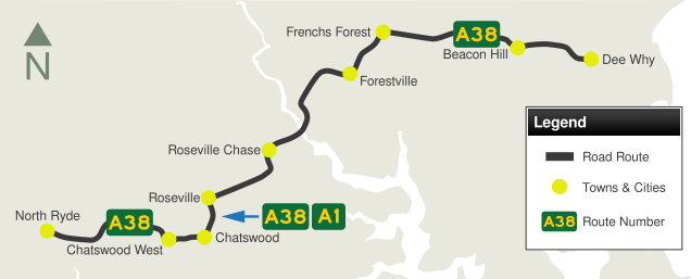
Delhi Road, Millwood Avenue, Fullers Road, Boundary Street, Babbage Road & Warringah Road (A38) |
Statistics:
- Length: 18 km
- Western Terminus: Hills Mwy (M2) & Epping Rd interchange at North Ryde
- Eastern Terminus: Pittwater Rd (A8) at Dee Why
- Suburbs, Towns & Localities Along Route: Dee Why, Beacon Hill, Frenchs Forest, Forestville, Killarney Heights, Roseville Chase, Roseville, Chatswood, Chatswood West, Macquarie Park and North Ryde
Route Numbering:
- Former:

- Multiplexes: A1
- Road Authority Internal Classification: MR191 (North Ryde to Chatswood) & MR328 (Chatswood to Dee Why) 1
General Information:
A38 is an suburban arterial road linking Sydney's Northern Beaches with the suburb of Chatswood, as well as the Pacific Highway and the Hills Motorway. It's a mix of divided and undivided roadway, and passes through commercial and residential zones as well as some bushland. The route features the spectacular Roseville Bridge over Middle Harbour and Fullers Bridge over the Lane Cove River. A38 also acts as a small bypass of the Chatswood CBD, skirting it on the western and northern sides.
Multiplexes along the route include:
- A1 (Pacific Hwy), for 700 m, at Chatswood
History:
- 1918: Fullers Bridge was completed. The bridge was originally intended to carry a tram to the Field of Mars Cemetery, as the slope of Fullers Road was too steep for horses to negotiate. It is not known whether a tram service eventuated. Fullers Bridge has also been known as Jenkins Bridge, named after a family who settled in the vicinity in the 1860s. 2
- 1924: The original Roseville Bridge opened. It was a low-level two-lane bridge. It was located downstream of the current bridge, and connected Babbage Road to what is today called Healey Way, which is the entrance to Davidson Park within Garigal National Park. 3
- April 1966: Official opening of current Roseville Bridge. 4 The bridge was designed by Donald Maclurcan, who passed away in 1999. 5
- October 2009: Extension of the right turn from Warringah Road into Government Road. 6
- August 2010: Extension of the right turn from Babbage Road (eastbound). 6
- October 2010: Extension of the right turn from Warringah Road into Wakehurst Parkway. 6
- 2013: SR29 replaced by A38.

| |
| |
 |
Advance Directional Sign:
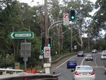
Westbound AD sign on Epping Rd approaching the junction with Delhi Rd (A38) at North Ryde, January 2017.
Image © Stuart Fox
|
|
 |
Advance Directional Sign:
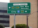
AD sign at Chatswood on Pacific Hwy (A1) approaching Fullers Rd (A38), January 2017. The A1 duplex ends at this junction.
Image © Spenser Tan |
 |
Intersection Directional Sign:
ID sign assembly at the corner of Epping Rd and Delhi Rd (A38) at North Ryde, January 2017.
Image © Spenser Tan
|
|
 |
Intersection Directional Sign:
ID sign at the corner of Pacific Hwy (A1) and Fullers Rd (A38) at Chatswood, January 2017.
Image © Spenser Tan |
 |
Hills Motorway Interchange:
Delhi Rd (A38) at the interchange with Hills Mwy (M2) at North Ryde, January 2017.
Image © Spenser Tan
|
|
 |
Reassurance Directional Sign:
RD sign at Chatswood, January 2017.
Image © Spenser Tan |
 |
Lady Game Drive:
Delhi Rd (A38) at the Lady Game Dr junction at Chatswood West, January 2017. A38 becomes Millwood Av at this point.
Image © Spenser Tan
|
|
 |
Advance Directional Sign:
AD sign on Delhi Rd (A38) approaching Hills Mwy (M2) & Epping Rd interchange at North Ryde, January 2017.
Image © Spenser Tan |
 |
Advance Directional Sign:
AD sign at Chatswood approaching Pacific Hwy (A1), January 2017. The A1 duplex begins at this junction.
Image © Spenser Tan
|
|
 |
Intersection Directional Sign:
Delhi Rd (A38) at the interchange with Hills Mwy (M2) & Epping Rd at North Ryde, January 2017. This is the western terminus of A38.
Image © Spenser Tan |
 |
Intersection Directional Sign:
ID sign at the corner of Pacific Hwy (A1) and Fullers Rd (A38) at Chatswood, January 2017.
Image © Spenser Tan |
|
|
|
 |
Intersection Directional Sign:
ID sign at the corner of Pacific Hwy (A1) and Fullers Rd (A38) at Chatswood, January 2017.
Image © Spenser Tan |
|
|
|
 |
Reassurance Directional Sign:
RD sign at Chatswood, January 2017.
Image © Spenser Tan |
|
|
|
1 Roads and Maritime Services, Schedule of Classified Roads and Unclassified Regional Roads, 30 January 2014
2 New South Wales Office of Environment & Heritage, Heritage Database, Fullers Bridge Over Lane Cove River
3 POIDB.com, Roseville Bridge - Killarney Heights NSW
4 Flickr, Highplains68, Roseville bridge construction The bridge was designed by Donald Maclurcan, who passed away in 1999.
5 State Library of New South Wales, Manuscripts, Oral History & Pictures, Collection Record Details, Donald Maclurcan papers, 1953-1982
6 Roads & Maritime Services, Pinch Point & Congestion Initiatives
Last updated: 02-Jan-2019 19:22
This site © Paul Rands. All rights reserved. Some portions © (copyright) by their respective and credited owners. Permission must be obtained before using any images from this site. For details, please email by clicking here.

